

HALIBURTON HIKING AND BIKING TRAILS
Haliburton Forest is full of variety and the hiking trails are no exception. The 400km of trails make Haliburton Forest an ideal destination for three season hiking vacations – you never have to explore the same trail twice. Stay overnight and walk as many routes as you can!
With a range of short and long hikes, you can download a map of the different hiking trails, or use the Haliburton Forest interactive trail map to plan your next hiking adventure.
Download ALL trail maps here in one PDF (2.64MB).

The Dahl Forest
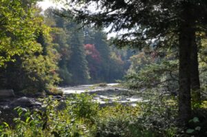
Burnt River at Dahl Forest
The Dahl Forest is approximately 500 acres and straddles 2.7 km of the Burnt River in Haliburton County 5 km south of Gelert. The ecological significance of the Dahl Forest is evident in the diversity of species and habitats found on the property.
The public is encourage to visit 5 km+ of trails at Dahl Forest for quiet day sports – hiking, cross-country skiing, snowshoeing and birding.
The Dahl Forest is located at 1307 Geeza Rd, off of Gelert Rd/County Rd 1 just 5 km south of Gelert. It is 20-25 minutes South of Haliburton or 15-20 minutes East of Minden.

Here are some recommended hiking routes through the Dahl Forest:
North Road Trail Loop (approx. 4 km measured from the trailhead - easy)
From the trailhead on Geeza Road, follow the main trail (Dahl Forest Access Road) to the North Road Trail. Turn left and follow the North Road Trail to the Concession Road (be sure to follow the right hand fork, not the Old Farmstead Trail). Turn left (west) on the Concession Road and walk until you reach the Old Farmstead Trail. Turn left and follow the Old Farmstead Trail until it intersects the North Road Trail. Turn right on the North Road Trail and follow it until you reach the Dahl Forest Access Road. Turn right and follow the signs to the trailhead.
Red Squirrel Trail Plus Black Rock Rapids Trail (approx. 0.6 km measured from the trailhead - moderate)
From the trailhead on Geeza Road, follow the main trail (Dahl Forest Access Road) to the Red Squirrel Trail turnoff. Turn right and follow the Red Squirrel Trail to the Black Rock Rapids Trail. Turn right and follow the Black Rock Rapids trail to the Burnt River. After viewing the river, return the way you came until you intersect the Red Squirrel Trail and turn right. Follow the Red Squirrel Trail until you reach the Dahl Forest Access Road and turn left towards the trailhead.
Big Bend Trail Loop (approx. 1.8 km measured from the trailhead - easy)
From the trailhead on Geeza Road, follow the main trail (Dahl Forest Access Road) to the Big Bend Trail Loop. Turn right on the Big Bend Trail Loop and keep going straight at the fork to hike the loop in a clockwise direction. Once you return to the intersection point, turn left. You'll come to the Dahl Forest Access Road. Turn left towards the trailhead.
Ridge Trail Loop (approx. 3 km measured from the trailhead - moderate)
From the trailhead on Geeza Road, follow the main trail (Dahl Forest Access Road), past the junction with the North Road Trail until you come to the intersection with the Big Bend Trail. Turn left. At the next junction with the North Road Trail, turn right onto the Big Bend Trail. Follow the loop around until you return to the junction with the North Road Trail. This time, take the North Road Trail towards the trailhead. When you come to the intersection with the Dahl Forest Access Road, turn right towards the trailhead.

Barnum Creek Nature Reserve
Features: Three hiking trails (total of 7km), forests, open fields, wetlands, Barnum Creek
Activities: hiking, cycling (restricted to Heritage Hike trail), snowshoeing, cross-country skiing, plein air painting, photography, bird watching
Not Allowed: hunting, motorized vehicles (including snowmobiles and ATVs), fires, overnight camping, harvesting and/or disturbing flora and fauna
Trail Safety & Etiquette: Please take only memories and leave only footprints! Dogs must be on a leash, so they don’t disturb sensitive flora and fauna habitats. Please clean up after them, do not leave anything on the trails, and take dog waste bags home for disposal.
Location: #1118 Gould Crossing Road (Google Maps mistakenly calls Gould Crossing Road, Cowan Road. There are two signs together on Gelert Road. One says Gould Crossing Road, the other Barnum Creek Nature Reserve.)

Explore The Trails at Abbey Gardens
Home to some of the best hiking trails Haliburton offers with 5 km of nature walks through Abbey Gardens. Their Haliburton trails are free to explore year-round, with guided nature hikes available. Whether wondering where to go hiking in Haliburton or seeking family-friendly Haliburton hiking and biking trails, our network welcomes all skill levels. https://www.abbeygardens.ca/ab...
Trail Highlights:
- Transitions Trail (1.2 km) - Experience the transformation from gravel pit to thriving ecosystem
- Chickadee Trail - Feed friendly birds along this family-favorite winter path (seeds $2 at Food Hub)
- Forest Network - Scenic woodland trails perfect for hiking and biking adventures
Family Fun Activities
- Explore the Enchanted Forest, a favorite spot for family day trips in Ontario
- Enjoy snowshoeing and fat biking on groomed trails (equipment rentals available for $10)
- Experience guided nature hikes with our knowledgeable staff (groups of 10+)

Ganaraska Trail to Sheldon Lake
6.4km Length - 149m Elevation gain - 1h 39m Estimated time Out & back Experience this 6.4-km out-and-back trail near Minden Hills, Ontario. Generally considered a moderately challenging route, it takes an average of 1 h 39 min to complete. This is a popular trail for backpacking, birding, and camping, but you can still enjoy some solitude during quieter times of day. The best times to visit this trail are April through November. Dogs are welcome and may be off-leash in some areas.
This is a proper wilderness hike. The first part of the trail is in excellent condition, and is well-marked and easy to follow. By the beginning of August, the mosquitoes are less annoying than in early summer. The trail is more manageable in the fall with young families when there are fewer bugs, and the trails are easier to follow with less water.
The beaver dams and water crossings are normally not a challenge, but would probably be considerably harder at a wet time of year. The planks are fairly wobbly.
Overall, this is a QE2 favourite, and most hikers come back multiple times.

CIRCUIT of 5 VIEWPOINTS
Map: AlgonquinTrails.pdf
Length: 5 km loop
Difficulty: Moderate - challenging
Trailhead Address: 2029 Little Hawk Road (County Road 13) – From Highway 35 North in Halls Lake, travel east on Little Hawk Road and proceed to the trailhead.
GPS Location: UTM Zone 17. T 0679034E 50000120N
Description: Hike 5 km along classic Canadian Shield country overlooking rugged valleys, placid rivers and amazing fall colours!

DORSET SCENIC LOOKOUT TOWER
Map: DorsetTower.pdf
Length: 1.5 km loop
Difficulty: Challenging
Trailhead Address: From the bottom: 1038 Main Street, Dorset. From the top: 1154 Dorset Scenic Tower Road (off of Highway 35 North, just north of the Town of Dorset).
GPS Location: UTM Zone 17. 0665302E 5012916N
Description: A challenging hike from the Dorset Museum to the top of the ‘Dorset Mountain’ where one can climb the steps up the 25m Fire Tower and view a panorama of 800km² of forest and numerous lakes. This is a must-see for anyone wanting to truly experience the Highlands. This trail can also be hiked from the top of the ‘Dorset Mountain’ down to the museum. If you want to start at the top (option available May to October), a fee to drive up to the access point/picnic area is applicable. During the open season there’s also a gift shop/visitor information centre, washrooms and numerous photo opportunities at the top of Dorset Mountain. Please see the Dorset Tower page for more information.

Things To Do And See Year-Round While You Visit
Beaches – Biking & Cycling – Dog Sledding – Fall Colours – Fat Biking – Fishing – Geocaching – Golfing – Hiking – Ice Climbing – Ice Fishing – Maple Season – Nordic Skiing – Paddling Adventure – Downhill skiing & Snowboarding – Snowmobiling – Snowshoeing – Waterfalls